Oh, the Places You'll Go on the Twin Cities Lines!
- Josh Biber
- Jul 14, 2022
- 16 min read
Imagine visiting the Twin Cities in the early 1900s. Where would you go? How would you get there? How much will it cost? What's there to do? These are a few questions you may immediately be asking yourself.
The Twin Cities Lines was the public transit company of the Twin Cities in the late 1800s through the 1900s until the end of the age of streetcars. This transit company heavily advertised all of the interesting locations throughout the Twin Cities that their services could bring passengers to. Each pleasure trip they advertised could be taken within a half-day, perfect for a weekday night or a weekend afternoon. By 1911, the Twin Cities combined for over 383 miles of streetcar track, and by 1917 that number grew to nearly 450 miles of track. At the time, the Twin Cities Lines were regarded as one of the most progressive electric transportation companies in the United States. Providing the best equipment and best service that money, skill, and enterprise can produce. At 47-feet long, the streetcars could fit 50 passengers comfortably.

To the visitor who wished to see interesting places in around the Twin Cities of the early 1900s, they wouldn't be caught dead without the pamphlet How to See the Twin Cities: St. Paul and Minneapolis. This tri-fold pamphlet contained a fresh-air guide of all the beautiful and interesting places in and around the Twin Cities that one could get to via streetcar.
To Visitors, Minneapolis was advertised as The Flour City - having both industry and several glistening leisure lakes. Then there was St. Paul, The City on Seven Hills, enthroned on the high cliffs of the deep-gorged Mississippi River valley, which binds the two cities together with it's ever-flowing waters. Streetcar getaways can be categorized as follows: to the west, to the east, staycations in Minneapolis, and staycations in St. Paul.

Trips to the West
FROM MINNEAPOLIS - take an electric train at 6th St. Station. Distance - to Deephaven, 17 miles; to Excelsior, 18 miles; to Tonka Bay, 21 miles. Time - to Excelsior or Deephaven, 46 minutes; to Tonka Bay, 55 minutes. Fare - each way ¢25, or ¢20 with a transfer from any Minneapolis local line.
FROM ST. PAUL - take a Selby-Lake or Snelling-Minnehaha car and transfer to train for Lake Minnetonka at Hennepin Ave., Minneapolis. Or take a Como-Harriet, or Minneapolis & St. Paul car and transfer to train for Lake Minnetonka at 6th St. Station, Minneapolis. Fare - each way, ¢30, or ¢25 with a transfer from any St. Paul local line.
-How to See the Twin Cities: St. Paul and Minneapolis, 1917
The Dakotan word for Big Water, Lake Minnetonka was first charted by Joseph R. Brown in 1822 when he canoed up Minnehaha Creek from Fort Snelling. At nearly 22 square miles, 125 miles of shoreline, 14 islands, 24 bays, and deep clear waters perfect for fishing and water sports, Lake Minnetonka instantly became a popular getaway for settlers and vacationers alike.

Of all the locations that the streetcars could take you in the Twin Cities, the route to Lake Minnetonka was noted as the most scenic. From downtown Minneapolis, the journey started as it passed by Loring Park's picturesque 36 acres of parkland. The trolley continued its journey along the southeastern edge of Bde Maka Ska as it spanned a bridge over West 36th St. The track quickly plunged into the woods of Cottage City (north of present-day Linden Hills) as it the climbed up the bluff that overlooks Lake Harriet. From Linden Hills, the train turns west for a 14-mile stretch of track that leads to Excelsior. This stretch of right-of-way offered a panorama of meadows, hills, lakes and streams that gave this stretch its name of The Line of Greenery and Scenery. One of the main stops on this stretch was at the Hopkins Depot.
Established in 1893, Hopkins emerged as a bedroom community of roughly 4,000 residents by the end of World War I. As a bedroom community, many residents of Hopkins had places of business in Minneapolis, making the daily trip back and forth via the Twin Cities Lines. Hopkins was known largely for its garden produce, fruits, and dairy products. This is remembered today by the City's seal which contains a raspberry. The bustling suburb also boasted wide avenues and well-kept shaded streets with crafstman-style homes. The Hopkins Women's Improvement League and Business Men's Association guided the destinies of Hopkins in both civic and economic matters.
Once in Hopkins, one could continue their journey to Lake Minnetonka in the form of two choices: by way of Excelsior to the Excelsior Dock Station, or by way of Deephaven to the Minnetonka Yacht Club terminus. at 60 miles per hour, the streetcar made either journey from Hopkins in about 20 minutes. Some passengers chose to partake in the scenic belt trip, which consisted of the streetcar journey to Deephaven, a 30-minute express boat trip to Excelsior (with a stop at Big Island Amusement Park), followed by a return to Minneapolis via the Excelsior streetcar line.
Big Island Amusement Park was one of the most frequented destinations operated by the Twin Cities Lines. First opened in 1906, Big Island Amusement Park often saw guests in excess of 10,000 visiting the park on summer weekends. Since the amusement park was located on an island, Twin Cities Lines operated a ferry boat and express boat service that would bring guests to the island via Deephaven, Excelsior, and Wayzata. The park featured picnic areas, a rollercoaster, music halls, rowboats, a carousel, as well as a 200-foot tall lighted beacon designed by LeRoy Buffington (1847 - 1931).

The amusement park at Big Island was short-lived however, owing to high operating costs and a short summer season. By 1911, Big Island Amusement Park was shut down. The Twin Cities Lines attempted to maintain ridership out west and began to advertise Excelsior as the summer go-to.
Founded in 1853 by a group of emigrants from New York, Excelsior's population climbed to just over 1,000 by 1917. Excelsior was a fine example of a prosperous community: having paved streets, hotels, summer cottages, restaurants, a business district, churches, electricity, and connection to rail, the city was making a name for itself. The Woman's Club of Lake Minnetonka and The Excelsior Commercial Club look after the welfare of the town.
Still an attraction today, the Twin Cities Lines boasted the Excelsior Commons as a destination for Minneapolis and St. Paul residents looking for a day trip. A slice of wooded hills and dales on Lake Minnetonka, The Commons were dedicated to the people by the original settlers of Excelsior. The Commons provided a space for people to have free access to fishing, lake sports, swimming, and bathing without charge. To this day, The Commons is still a great attraction in Excelsior, offering panoramic views of Lake Minnetonka, and three ice cream parlors just a short walk away.
As aforementioned, the quick, pleasant, inexpensive way to skirt around Minnetonka's shores and enjoy its secluded charms was to get aboard one of the six Express Boat of the Twin Cities Lines fleet. These boats offered rapid transit between the streetcar terminals on the lake shore and all principle points of Lake Minnetonka at frequent intervals with clock-like regularity. Named after famed destinations reached on the Twin Cities Lines: Como, Harriet, Hopkins, Minnehaha, Stillwater, and White Bear. At 70 feet long and 14 feet beam, torpedo sterns and comfortably seating 120 passengers, the express boats remained a popular tourist destination long after the Big Island Amusement Park shuttered its doors. The express boats passed beautiful islands, handsome cottages, traveled picturesque channels, and delightful bays. It was advertised, "there is no pleasanter way to spend an afternoon or evening than by riding on these boats." Today, only one express boat remains, The Minnehaha. Unfortunately, the Minnehaha offered its last ride in 2019 - the boat is currently looking for a new launch site to return her passenger service.

Trips to the East

FROM ST. PAUL - take an electric train at Seven Corners Terminal. Distance - to Wildwood Park, 12 miles; to White Bear Town, 16 miles; to Stillwater, 20 miles; to State Prison, 23 miles. Time - to Wildwood Park, 48 minutes; to White Beat Town, 66 minutes; to Stillwater, 69 minutes; to State Prison, 81 minutes. Fare - each way, to Wildwood Park, ¢15; to White Bear Town, ¢20; to Stillwater or State Prison, ¢30. With transfer from any St. Paul local line, ¢5 less in each case.
FROM MINNEAPOLIS - take any interurban car for St. Paul and transfer train for Stillwater. From St. Paul & Minneapolis or Como-Harriet cars transfer at Seventh St. From Selby-Lake or Snelling-Minnehaha cars transfer at Seven Corners Terminal. Fare - each way, with transfer from any Minneapolis local line, ¢5 more in each case than above.
Just as Lake Minnetonka and the surrounding towns were a close getaway for Minneapolis residents, White Bear Lake and Stillwater became natural choices for St. Paul residents looking for a weekend staycation.
Taking the streetcar past North St. Paul, Silver Lake, Long Lake, with pleasant farmland and enchanting greenery all around, the streetcar would rumble into Wildwood Park where passengers were greeted by fun delights of summertime. Wildwood Park was on the southeast shore of White Bear Lake. Just as Big Island Amusement Park was operated by Twin Cities Lines at its western terminus, Wildwood Park was the sister park also owned by Twin Cities Lines. Known as the Twin Cities' ideal picnic resort, Wildwood Park's handsome brick pavilion attracted tens of thousands of guests each summer. Wildwood Park operated a restaurant, refreshment vendors, a dance hall, hot air balloons, promenade, and observation dock that overlooked White Bear Lake. In 1916, the park unveiled a bath house and cleared shore for a sandy beach for swimming and relaxing by the water. If you caught the streetcar schedule just right, you could make it in time for the orchestral concert series that took place every Sunday afternoon from May 30 through September 1. For those looking for a little extra excitement, Wildwood Park offered lawn bowling, playgrounds, swings, a roller coaster, carrousel, a water ride, and fishing and boating excursions. No trip to White Bear Lake or Stillwater was complete without a day trip to Wildwood Park.
Wildwood Park proved to be much more successful than Big Island Amusement Park; However, just like its sister park to the west, Wildwood Park too eventually became too expensive to operate. By the early 1930s, automobiles started to become attainable for the middle class, and transit ridership was decreasing year over year. By 1932, the Twin Cities Lines made the tough decision to close Wildwood Park. Over the next few years, the land formerly occupied by Wildwood Park was piecemealed to developers.

A ride on the streetcar from Wildwood Station west towards White Bear Town took just under 20 minutes with a few stops in between. The route of the streetcar to White Bear Town snaked through the woods not too far from the lake's edge. Crossing the isthmus between White Bear Lake and Goose Lake, the woods opened up to White Bear Town.
First settled by European immigrant V.D. Barnum in 1849, White Bear Lake's population had already surpassed 2,000 by the end of World War I. By the mid 1910s, White Bear Lake emerged as a popular resort town for tourists escaping Minneapolis and St. Paul for the summer. For those looking for a watery excursion, the White Bear Lake Yacht Club boasted a handsome clubhouse near Dellwood on the northeastern shore of the lake (still in operation to this day). For those more inclined to stay shoreside, the St. Paul Automobile Club had a regal clubhouse at the southern edge of town (where present-day Kowalski's is located in White Bear Lake). With yachting and driving in the summer, skating and ice-fishing in the winter, and resorts offering amusements year-round; White Bear Lake became a popular place for St. Paul's elite to purchase summer residences.

Just eight miles to the east from Wildwood Park on the streetcar line was the town of Stillwater. At over 10,000 residents by the late 1910s, Stillwater was considered one of the larger cities outside of the Twin Cities. Stillwater-on-the-St. Croix offered panoramic views of the river and bluffs surrounding the city. Stillwater too became a popular location for fishing, boating, and other water activities. Apart from the leisure activities that the St. Croix River offered, the city also boasted a modest downtown district owing to the fact that Stillwater was once a logging and lumbering powerhouse. For many decades in the 1800s, loggers would cut down the forested banks of the St. Croix to the north of Stillwater - sending the timber downstream to be milled in the city. As the logging industry slowly dwindled by the turn of the century, other industries and manufacturers took place of the quickly vanishing mills.
Stillwater recognized that the decline in the lumber industry could be detrimental for their community. Considering their population decline, Stillwater attempted to appeal to Americans looking to relocate from the eastern United States as well as Europeans looking to settle in Minnesota by likening the St. Croix River to that of the Hudson and Rhine Rivers respectively. Stillwater double downed on its marketing scheme by advertising itself as The Homiest Town in the Country, the community saw a large increase in families who built large Victorian homes on the bluffs above the St. Croix. Conversely as new families were moving to the city, laborers and workers left en masse towards new employment prospects in St. Paul and Minneapolis. From 1900 through 1920, Stillwater saw a net decline of roughly 5,000 residents. The Stillwater Civic Club sought to advertise the city to families and vacationers alike.
The Minneapolis Chain of Lakes by Streetcar
FROM MINNEAPOLIS - To Lake Harriet - take any car for Lake Harriet. Fare - each way, ¢5. To Lake of the Isles, [Bde Maka Ska], Calhoun Beach and baths -take a St. Louis Park or Calhoun Beach car to Lake St. Landing or Calhoun Beach and Baths. Or take a Selby-Lake or any Lake Harriet car to Hennepin Ave. and Lake St. and walk along Lake St. a short distance, to Lake St. Landing. Fare - each way, ¢5.
FROM ST. PAUL - take a Selby-Lake, or Como-Harriet car to Hennepin Ave. and Lake St. and follow the same directions. Fare - each way, ¢10.

If Lake Minnetonka and White Bear Lake were popular destinations on the Twin Cities Lines, the Minneapolis Chain of Lakes - Lake Harriet, Lake Calhoun (now Bde Maka Ska), Lake of the Isles, Cedar Lake, and Brownie Lake - were the most frequented tourist destination in the Twin Cities. Early on in Minneapolis' history, city officials saw the importance that these lakes brought to the community. One of the Park Board's first major works project was enhancing these lakes for the public. The Park Board did so by connecting Bde Maka Ska, Isles, and Cedar by channels. The Park Board also considered digging canals through Cottage City and Linden Hills to connect Bde Maka Ska to Lake Harriet to the south, but that's a story for another day. After the channels were dug to connect the lakes, the city dredged shallower sections of the lakes. In doing so, they were able to turn swampland near the lakes into land purposed for boulevards. Except for a small section of Cedar Lake, The Park Board was able to save nearly all of the shoreline 'round these four lakes as parkland. Paths wind under a canopy of trees along the shores of the lakes, giving way to fantastic views of the surrounding neighborhoods and city.
During the summer months, the Minneapolis Park Board operated steamboats Three Lakes and Maid of the Isles for panoramic tours of Bde Maka Ska, Lake of the Isles, and Cedar Lake. A tour of the three lakes via the steamboats was offered at ¢25 for a 90-minute leisurely journey. The views from the steamboats were fantastic, offering sightlines to the Minikahda Club and Lakewood Cemetery via Bde Maka Ska, islands and premier homes via Lake of the Isles, and bluffs and beaches via Cedar Lake.
Alluded to above, the Lakewood Cemetery quickly became an institution as one of the most notable burial places in Minnesota, sprawling over 240 acres in southwest Minneapolis. The cemetery is a park in its own right. With dales & knolls, wooded groves, views of the lakes, a willow tree relocated from Napoleon Bonaparte's grave, and winding drives, Lakewood Cemetery was and still is a landscape architects dream.

Directly to the south of the cemetery sitting squarely in southwest Minneapolis lies Lake Harriet, the southernmost lake of Minneapolis' four chain of lakes. Lake Harriet was one of the more popular lakes of the chain due to Harriet's close proximity to the streetcar station and access to public beaches. Harriet's first European-settled history can be traced back to 1835, when Reverends J.D. Stevens and Gideon Pond erected a school house just north of where the Como-Harriet Streetcar Depot is located.

The lake's largest attraction for streetcar-goers was the Lake Harriet Concert Pavilion, erected in 1892. The first pavilion burnt down in 1903, the Park Board quickly responded by constructing the second iteration of the pavilion in 1905 with additional funds provided by the Twin Cities Lines. The second pavilion was one of the first Park Board buildings outfitted with electricity, the pavilion was noted for being beautifully illuminated at night.

The Minneapolis Municipal Band frequently serenaded crowds of up to 6,000 with a summer concert series at the pavilion. The second Lake Harriet pavilion suffered a devastating fate in 1925 when the structure was destroyed by a tornado. The current bandshell and pavilion that we know today was constructed in 1986. In addition to concerts, Lake Harriet offered plentiful picnic spots around the shores, as well as wooded groves such as Berry Park where children would play.
Just east of Lake Harriet stands the Minneapolis Rose Garden for those looking for a little stroll from the Harriet streetcar station. Just as it was 100 years ago, the Rose Garden still offers guests free admission to see over 250 different varieties of plants and flowers.
For those looking for a journey on the waters of Lake Harriet, one could wait at the 42nd St. dock to be picked up by steamboat for a panoramic tour. For ¢10, guests could enjoy a 25-minute round trip on the lake. Prices were halved if guests flashed the first mate their Twin Cities Lines streetcar tickets of the same date.
It is easy to see why visitors and travelers to the Twin Cities could easily spend a full day exploring the interesting shores and cruising the charming city lakes.
Minnehaha Falls and Southeast Minneapolis
FROM MINNEAPOLIS - take a Snelling-Minnehaha or Minnehaha Falls car. Fare - each way, ¢5.
FROM ST. PAUL - take a Snelling-Minnehaha car. Fare - each way, ¢10.
Minnehaha Regional Park was the Mecca for thousands of visitors to the Twin Cities, and a favorite haunt for residents from both Minneapolis and St. Paul. Carefully preserved, the park retains the natural features of the falls as well as the romantic Longfellow Glen below them. There were countless attractions in close proximity to the falls: the Minnesota Soldier's Home and its naval guns from Admiral Cervera's Spanish ship Maria Theresa from the naval battle of Santiago, July 3, 1898; the Longfellow Zoo & Gardens with access to bears, camels, monkeys, porcupines, and wolves; Colonel John H. Stevens home, which was the first building erected in Minneapolis on the west side of the river; and Fort Snelling, where the Snelling-Minnehaha streetcar line continued into St. Paul. All these attractions were but a few steps from the streetcar landing stations.
Lake Como and Como Park
FROM MINNEAPOLIS - take a Como-Harriet car. Fare - each way, ¢10.
FROM ST. PAUL - take a Como-Harriet car. Fare - each way, ¢5.
Just like Minneapolis and its Chain of Lakes, St. Paul too boasted Como Park, famous for beautiful landscape gardening. One of the most visited attractions on the streetcar lines, Como Park often drew crowds in excess of 20,000 each weekend. Visitors to Como Park were greeted by perhaps the most beautiful station on the Twin Cities Lines. The artistic Como Park station was built in a cobble stone fashion. Just like it was a century ago, visitors to Como Park can walk under a canopy of vine-covered trees to find all the surprises and delights that the park provides.
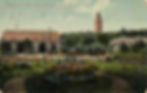
Como Park provided access to amazing spectacles: a Japanese garden with bonsai trees, tropical and native plant ponds, a buffalo preserve, tennis courts, flower gardens, and the Marjory McNeely Conservatory which was erected in 1915 at the cost of $100,000. In addition to the parkland, Como Park had miles of pathways and boulevards, the latter which could be toured in automobiles operated by the St. Paul Park Commission. At the time, Como Park was equaled by few other parks in the nation.
Phalen Park and Lakes
FROM MINNEAPOLIS - take a Phalen Park car for Phalen Park. Fare - each way, ¢5.
FROM ST. PAUL - take any interurban car and transfer in St. Paul. Fare - each way, ¢10.
In 1917, Phalen Park was one of the newest additions to St. Paul's parks, and the Twin Cities Lines sought to capitalize on this by building a spur line to connect the park to their streetcar network. Surrounded by hills and wooded groves, Phalen Park offered six lakes ideal for water recreation. Phalen, Round, Keller, Spoon, Gervais, and Kohlman lakes were connected by channels wide enough to explore via canoe, with the more northern lakes large enough to support motorboats. Visitors to Phalen Park could rent both canoes and rowboats to meander the plentiful lakes and canals. However, many chose to simply take a dip at the sandy beach and wash off in the newly constructed stucco bath house. Bands and orchestras would serenade thousands of guests at the lake shore pavilion like many of the other parks in St. Paul and Minneapolis.

There truly were so many places that one could visit via the Twin Cities Lines that they can't all be mentioned. In Minneapolis, some of the additional attractions often visited by streetcar were Glenwood Park and Lake (now Theodore Wirth Park), the University of Minnesota campus, the Minneapolis Institute of Arts, the Ard Godfrey house, St. Anthony Falls, the Minneapolis Chamber of Commerce Building, Minneapolis Court House and City Hall, and West River Parkway via the Selby-Lake line.
St. Paul too had plenty additional popular streetcar destinations including Harriet Island, Indian Mounds Park, the Capitol building, the St. Paul Public Library (now the George Latimer Central Library), the now-defunct Selby Subway, St. Paul's Municipal Auditorium, and the Minnesota State Fairgrounds.
The Twin Cities Lines reached its peak in the early to mid-1920s. In the five years from 1917 to 1922, Twin Cities Lines increased their track mileage to over 520 miles and operated over 900 streetcars. Numbers vary, but roughly 200 million passengers used the streetcar per year in its heyday. Unfortunately, this heyday was short lived, and by the 1930s, the automobile was king. Ridership was nearly halved from 1920 to 1930.
The Great Depression also played a role both for and against the Twin Cities Lines. On one hand, the automobile became out of reach for many families thus the streetcar was a preferred method of transportation; on the other hand, Twin Cities Lines had to close their suburban routes to the west and east, and closed Wildwood Park all to save costs.
The streetcars saw a brief renaissance of increased ridership during World War II owing to rations on gasoline. However, this too passed and by the 1950s the white exodus to the suburbs was in full swing; automobiles became the preferred mode of transportation for these families. The Twin Cities Lines sought to new management in the late 1940s. This new group of management ripped out the streetcar lines in exchange for asphalt, a new fleet of 525 General Motors busses were delivered, and the streetcar made its last journey on June 19, 1954.
However, all is not lost! To preserve the history of the streetcars, The Minnesota Streetcar Museum was formed in 1962. Since 1971, the museum has offered streetcar ridership aboard a portion of the Como-Harriet line between Bde Maka Ska and Lake Harriet. In addition, the museum has operated a short stretch of streetcar line in Excelsior since 1999. Both make for great weekend activities in the summer - much like they did a century ago.

Sources:
Twin City Rapid Transit. How to See the Twin Cities, St. Paul, Minneapolis, Parks, Falls, Mounds, Minnesota. 1911. Minnesota Streetcar Museum, collection.mndigital.org/catalog/msn:519 Accessed 1 July 2022.
Lake Harriet pavilion, Minneapolis, Minnesota. 1910?. Minnesota Streetcar Museum, collection.mndigital.org/catalog/msn:775 Accessed 8 July 2022.
Ruderman, B. L. "Beautiful Big Island Park and Lake Minnetonka. 1907." Antique Maps, Inc., raremaps.com/gallery/detail/68231/beautiful-big-island-park-and-lake-minnetonka-anonymous/ Accessed 11 July, 2022.
"Ellen and Sir Joseph Francis" Lakewood Cemetery. February 14, 2018, https://www.lakewoodcemetery.org/2018-02-14-lakewoodlovestories-ellen-and-sir-joseph-francis/
Isaacs, A. "Historic Como Park Ped Bridge Restored" Streets.mn. September 12, 2015, https://streets.mn/2015/09/12/historic-como-park-ped-bridge-restored/
Huynh, K. "Twin Cities Streetcars - The Rise and Fall" Minnesota Digital Library. https://mndigital.org/projects/primary-source-sets/twin-cities-streetcars-rise-and-fall Accessed July 12, 2022.
Twin City Rapid Transit. The Twin Cities Today, 1917, Minnesota. 1917. Minnesota Streetcar Museum, collection.mndigital.org/catalog/msn:473 Accessed 7 July 2022.